GraphicalData now has Google Mapping
GraphicalData has implemented Google's earth aerial mapping as part of the presentation for each listing pulled up on a GD web site.
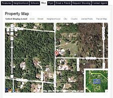
What does this mean...well, if you pull up a listing in a GD environment, then select the "map" feature button, you have several options. You can view the default "street" level mapping, or select the "neighborhood" level, or the "city" level, or even the "county" level. The new "aerial" level now maps to real virtual earth...cool!
And for Portland and Seattle, another bonus for selected areas...a "parcel map" shows as well!!! Other areas will be phased in on this one as resources permit...
More information for your visitors...more reasons you can use to promote your website...and why folks need to visit. And ultimately more leads for you...
Stay tuned for even more exciting tools coming online...near you...soon!
posted by Ozzie Nohre @ 2:01 PM
![]()
![]()


<< Home